With a goal to reach a total land size of 76,600ha by 2030, compared with the 71,990ha last year, this little red dot still has some growing to do. This will help accommodate around 6.5 million to 6.9 million residents by then, as set out in the 2013 Population White Paper and Land Use Plan. Insight looks at how Singapore is striving to find more space.
EMPOLDERING IN LAND RECLAMATION
It was across the globe, in the Netherlands, where Singapore found an answer for land reclamation.
It is not to buy sand. Instead, the Government has been studying a 2,000-year-old Dutch reclamation method that can reduce the need for imported sand.
Known as empoldering, the method is expected to save Singapore 40 per cent in sand volume and construction cost, reveals National Development Minister Lawrence Wong – the first time such figures have been made public since works began in 2016.
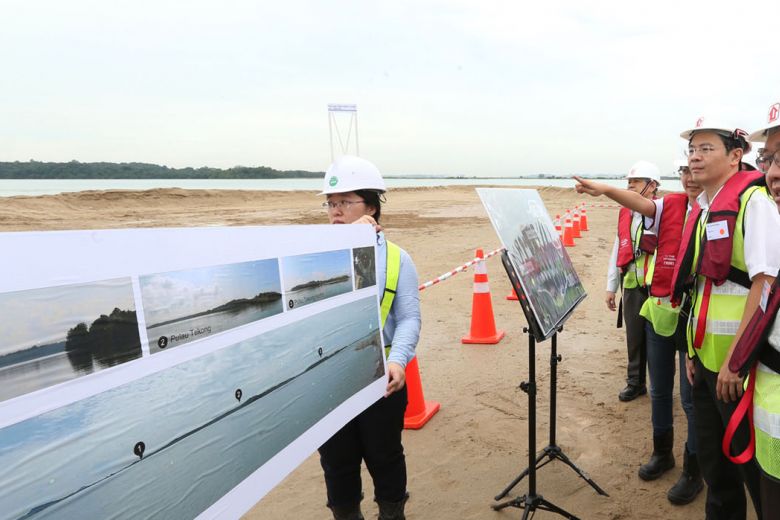
The Government has adopted the method in reclamation works in Pulau Tekong. When completed in 2022, the island will grow by around 810ha, the size of Toa Payoh, to be used for military training purposes. This frees up space on the mainland – the Housing Board is already developing the upcoming Tengah New Town in that space.
“I think that looks very promising,” says Mr Wong about the method. “We always look for alternatives. Because we know that land is limited and one of our strategic objectives is to preserve our options for future development.”

Empoldering involves building a dike around the area to be reclaimed, then draining the water from it, creating a low-lying tract of land below sea level known as a polder. Water levels in the polder are controlled by drains and pumps.
Empoldering is likely to grow in use amid challenges that Singapore is facing in finding sand. [caption id="attachment_24107" align="aligncenter" width="780"]
 Mr Lawrence Wong (right) on a site visit at Pulau Tekong in 2016, where empoldering is being used in reclamation works. The method involves building a dike around the area to be reclaimed, then draining the water from it, creating a low-lying tract of land below sea level known as a polder. ST PHOTO: LAU FOOK KONG
A 2014 United Nations Environment Programme report described Singapore as the world’s largest importer of sand.
Last year, Cambodia banned all sand exports to Singapore on environmental grounds. Despite a temporary ban already in place since 2016, local environmental groups alleged that sand had still been exported illegally to Singapore.
Asked about this, Mr Wong says the government agencies which conduct land reclamation do not procure from illicit sources.
“The key thing is that all procurement agencies that procure sand from commercial providers will require requisite permits from the source countries – that is the ultimate check.
“We will not allow any commercial provider of sand to come in without a valid export permit.”
On how Singapore decides on its reclamation works, he says that while potential areas for reclamation have already been identified, not all are carried out at once.
“If we are clear that there is a developmental need to expand, for example, in Tuas or Changi, then yes, we will embark on reclamation.
“In doing so, we make sure that we do all the necessary impact assessments, environmental impact assessments and a range of studies to make sure that whatever we are doing is sustainable.”
These demands for land come from different agencies with various needs – ranging from residential and military to commercial and industrial.
But land reclamation is not the only option to maximise Singapore’s land use.
An underground master plan is currently in the works, mapping out what lies underneath Singapore’s surface and how much can be stored there.
Some plans have already taken shape, such as the storage of petrochemicals in the Jurong Rock Caverns under Jurong Island.
LAND INTENSIFICATION
Building higher is a possibility too, though there are height restrictions near airports and military airbases.
By 2030, the relocation of Paya Lebar airbase to Changi and Tengah airbases will free up a town-size 800ha of land, and also remove the height restrictions imposed by the airbase.
The next Concept Plan in 2021 will likely look into the potential for this newly freed up space, as well as for surrounding towns, says Urban Redevelopment Authority (URA) chief planner Hwang Yu-Ning.
Questions to be asked include whether Paya Lebar airbase can be replaced by a town that emphasises living, working and playing in the same space.
The blank canvas also gives planners an opportunity to explore how infrastructure can support the latest ideas and technologies.
“I think we’ll also be asking ourselves what will the future of mobility look like in the (next Concept Plan) and how it would influence travel patterns as we know it today,” says Ms Hwang, referring to new advances such as driverless cars and drone pods to carry people, a la The Jetsons, the American futuristic animated sitcom.
These wild ideas were inconceivable for the 2011 Concept Plan, but seem ripe for exploration now.
CO-LOCATION
Planners are also “actively looking” into potentially co-locating multiple services within the same estate or development, with some ideas taking shape on a smaller scale for now.
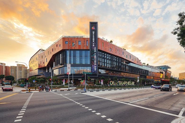
Our Tampines Hub, which is run by People’s Association (PA), is the first example of how various agencies can share the same physical location, instead of taking a parcel of land each.
Completed in 2013, the $500 million building features a Public Services Centre that connects residents to seven different agencies: PA, North East CDC, the Housing Board, Workforce Singapore, Ministry of Social and Family Development, ActiveSG, and National Library Board
Ms Hwang also cites how Pek Kio Community Centre, which was undergoing redevelopment, found an opportunity to co-locate with Farrer Park Primary School, becoming the first such project to do so.
“Now that they are co-located, there are potentially more synergies in the way the community can use the space,” she said, adding that students have been using the community centre’s cooking studio.
Co-location reaps the most benefits when it comes to planning for the aged. The integrated HDB development Kampung Admiralty, which opened last August, brings together medical and nursing care services within the residential development. This means a doctor is only a few steps away for an elderly resident living at Singapore’s first retirement kampung.
Space-saving ideas like these are not new around the world. In Japan, there are proportionally fewer nursing homes per elderly populace as most live within the community.
If planners should keep pace with this trend of integrated living, then they should be asking the right questions, Ms Hwang says.
“As Singaporeans age and see a larger number of elderly in our midst, the question is whether separate institutional care provides the best quality of life and sense of belonging in the community.
“Are accessible locations like Kampung Admiralty the best way? Or do people want more quiet respite?” asks Ms Hwang.
FLOATING BUILDINGS
In trying to make better use of available space, one exciting idea is to tap maritime space – building structures on large “floating vessels”.
While these concepts have not yet reached the realm of a city perched on a vessel, known as seasteading, this may be the way for Singapore to expand outwards without the need for land reclamation.
There are some explorations and research projects, but the rub is that there is currently a lot of demand on maritime space from ports and container ships, says Ms Hwang.
But it is still possible. The authorities are now exploring ideas on how to make vessel anchoring at offshore anchorages more efficient.
Currently, ships do not “park” neatly like cars as they drift in a circle around a single anchor, says Ms Hwang. One idea is to remove this drift by anchoring the ship at four points.
“With proper anchoring, we can make our sea space more efficient and potentially make ideas like floating vessels (that one can build structures on) be more practical to implement,” she says.
Whether the future may resemble The Jetsons or seasteads, all government agencies are in a “constant conversation” to decide what is the best way to use available land, says Mr Wong.
Be it through reclamation, building underground, or land optimisation, Singapore wants to “ensure as many options as we can in terms of maximising our development space”, he adds.
This article originally appeared in Straits Times.


