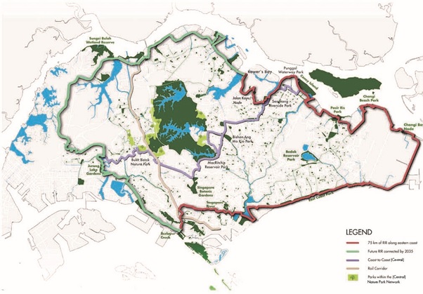
The National Parks Board (NParks) opened the first phase of the Round Island Route today. This recreational connection stretches 75km, from Rower’s Bay Park, through Sengkang Riverside Park, to Changi Bay and East Coast Park, past the Singapore River to Berlayer Creek. It will provide Singaporeans with more opportunities for nature-based recreation and bring them closer to greenery to experience its benefits on health and well-being. When completed, the 150km Round Island Route will be the longest recreational connection that loops the island and is part of NParks’ overall plans to curate a 360km island-wide network of recreational routes by 2035.
To commemorate the opening of Phase One of the Round Island Route, Deputy Prime Minister and Coordinating Minister for Economic Policies Heng Swee Keat, together with Second Minister for National Development and Finance Indranee Rajah, and Advisor for East Coast GRC, Dr Maliki Osman, visited the new park connector at Changi to the new node at Changi Bay Point along the Round Island Route. They also planted saplings of two native coastal plants, the Sepetir (Sindora wallichii) and Sea Beam (Maranthes corymbosa), with members of the community, including the Friends of Park Connector Network.
Eastern half of Round Island Route
First announced in 2012, the Round Island Route will be a continuous 150km route that links park connectors, looping around Singapore and connecting various parks, nature areas and places of interest for the public to explore.
The opening of the 75km stretch is part of the first phase of the Round Island Route, covering its eastern half. It also makes for the island’s longest recreational connection that encircles Singapore in the east, from Rower’s Bay Park in the north-east, past the Singapore River to Berlayer Creek in the south. Key parks along the route include Sengkang Riverside Park, Pasir Ris Park, Changi Beach Park and East Coast Park. This gives visitors a continuous connection across the east of Singapore, providing more opportunities for Singaporeans to immerse themselves in nature and explore the island and its green spaces.

The newly opened eastern half of the Round Island Route has several key features that leverage the coastal and riverine settings. Some of these features include bridges for connectivity, marine tiles along the coast to enhance habitats for marine life, otter holts to serve as rest areas and provide habitats for the local Oriental Small-clawed Otters, look out points at Changi Bay Point and Sengkang Riverside Park that offer sweeping vistas of the waterside, and scenic boardwalks that bring visitors closer to the coast.
Around 5,100 trees and shrubs – including native coastal and riverine tree species, such as Penaga Laut (Calophyllum inophyllum) and Small-Leaved Nutmeg (Knema globularia) – have also been planted along this stretch of the Round Island Route. This will provide visitors with shade and respite from the heat, as well as provide food and shelter for native biodiversity. For instance, certain sections of the route feature Seashore Mangosteen (Garcinia celebica) as food for small mammals. Flowering shrubs, such as Sea Lettuce (Scaevola taccada), were also planted to provide nectar for bees.
New nodes have also been introduced along the route at Changi Bay Point, Sengkang Riverside Park and Jalan Kayu. These nodes will serve as rest points for visitors of the Round Island Route. Amenities at the node include shelters with solar-powered charging points, bicycle parking lots and toilets.
NParks will continue to strengthen connectivity along the eastern half of the Round Island Route, widening selected paths with additional greenery and landscaping to enhance biodiversity and provide shade. This will make the route more user-friendly and enjoyable for all.
The rest of the Round Island Route will be progressively completed by 2035. This will enhance accessibility for residents in the area, as well as increase choices of recreational routes for Singaporeans.
Extending connectivity across Singapore
The development of the Round Island Route is part of NParks’ overall plans to curate a 360km island-wide network of recreational routes comprising park connectors and trails. This will expand and enhance connectivity across Singapore and provide opportunities for the community to explore our parks and nature areas, as well as walk or cycle in natural spaces.
Such island-wide routes will not only bring Singaporeans closer to greenery, enabling them to benefit from the positive effects of nature on their health and well-being, it will also connect communities and bring about a sense of space many times beyond our small island-city state. Additionally, the expansion and enhancement of these recreational routes will complement our plans to establish 500km of park connectors by 2030 and contribute to Singapore’s goal of enabling all households to live within a 10-minute walk of a park at the same time.
Besides providing more opportunities for nature-based recreation, the island-wide routes will also help to enhance ecological connectivity between natural habitats, thereby strengthening Singapore’s ecological resilience.
Altogether, these efforts will contribute to Singapore’s transformation into a City in Nature – a key pillar in the Singapore Green Plan, which is a national movement to advance sustainable development – to create a green, livable, and sustainable home for all Singaporeans.


