As data and mobility erase physical constraints, the shape of cities facilitates innovation and growth.
By 2050, 68% of the world is projected by the United Nations Department of Economic and Social Affairs (DESA) to be living in cities.
The abundance of opportunities and unstoppable growth makes cities attractive to people. People going to cities, on the other hand, further creates opportunities and accelerates growth — forming a positive feedback loop.
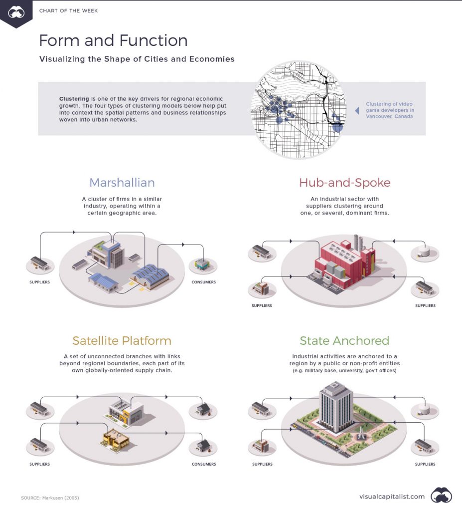
Economist Alfred Marshall proposed that the local clustering of industries in cities is among the key drivers of their growth. This is the driving concept of his Marshallian Industrial District.
Ann Markusen built on Marshall’s work and classified industrial districts in her work, Sticky Places in Slippery Space: A Typology of Industrial Districts.
Using the works of Marshall and Markunsen, Visual Capitalist illustrated the shapes of urban networks today.
Marshallian industrial districts
Marshall’s original formation of the industrial district is characterised by a region of small, locally owned firms. A Marshallian district possesses a group of enterprises with similar technical expertise, catering to the specialised services offered by the district.
Real-life examples: Clustering of social media marketing companies in San Francisco
Hub-and-spoke districts
Hub-and-spoke districts are dominated by a few large core firms surrounded by less powerful suppliers. Activities in this kind of urban network are centred on these key firms, distributed like spokes on a wheel.
Cooperation is prominent in hub-and-spoke districts. However, this cooperation tends to be on the terms of the anchor firm. With this, the loyalty of the labour market is to the firm first and the district next.
Real-life examples: Seattle, Toyota City
Satellite platform districts
Satellite platforms are unrelated, standalone facilities linked to large, externally situated firms. These districts can be thought of as the opposite case of hub-and-spoke districts which have large, locally-based firms. These districts, along with the latter, are the dominating city structures in the United States.
According to Markunsen, this configuration is often used by governments in order to stimulate development in outlying areas. On top of this, a satellite platform configuration can also lower business costs for competitively squeezed companies.
Real-life examples: Research Triangle Park, Maquiladoras
State-anchored industrial districts
This type of district is characterised by a military base, weapons lab, university, or an agglomerate of government offices acting as the anchor of activity.
Instead of private-sector firms, it is the government which is responsible for making the key decisions and establishing economic relationships in this district. With this, the loyalty of the labour market is to the state first before the district or the firms.
Real-life examples: University towns, Pearl Harbor
Knowing the shape of the city is important in policy, since this can aid in the formation of strategies that best fit the latent politico-economic structure. The shape of the cities also makes it easier to see the connections of the entities inside the city and to better understand the rationale of their decisions, both of which can help in discovering ways to boost growth.
References
Ann Markusen (1996) Sticky Places in Slippery Space: A Typology of Industrial Districts, Economic Geography, 72:3, 293-313, DOI: 10.2307/144402


